Dr. John Morris, G4ANB, is accredited with developing the Maidenhead (Grid) Locator system in 1980, which has been adopted worldwide by radio amateurs.
The grid locator system comes into its own particularly on VHF and above where stations are keen to record contact (QSO) distances.
Many VHF and above contests, such as the John Moyle Field Day, rely on stations knowing their grid locator so that points can be allocated based on the distance between stations.
The actual grid locator for a station’s location is derived from their latitude and longitude on the earth and generally consists of 2 letters, 2 numbers and 2 letters.
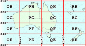
The whole world has been divided into grid squares . For Australia the first two grid square letters range from OH at the top western extreme of Australia to QE for Tasmania and to the east. In New Zealand only two grids cover the country, RF and RI.
 If you want to know what grid square represents your location, I recommend two references on the net.
The first calculates your grid locator based on an address or latitude/longitude. You can enter an address, city, state and postcode, or a callsign (the callsign address information is extracted from QRZ.COM).
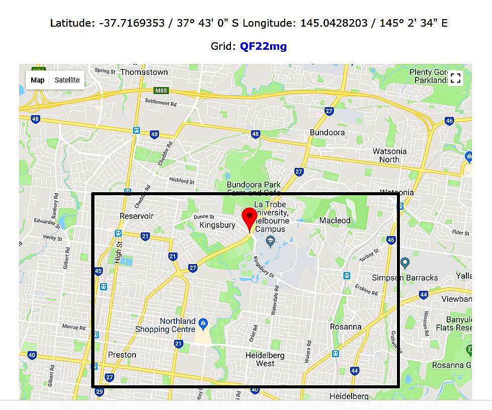
In this case I have entered an address of 1018 Plenty Road, Bundoora, Vicoria, 3083.
The result shows the latitude and longitude of the Maidenhead Grid Square calculated to be in QF22mg. The location is pinpointed with a red marker with a black dot at the top and middle of the outlined grid.
 A grid locator consisting of a 6 letter/figure combination measures approximately 4.82803 kilometres x 6.43738 kilometres (3 x 4 miles for those that use that “other” measurement system).
Once you have your station locator and that of a station contacted, Tiny Locator is a very useful tool to confirm the grid square co-ordinates and determine the distance between two grid squares. This is an excellent application developed by ON6MU.
In the John Moyle Field Day contest points are allocated based on distance between the working station and the worked station. Following is an example of scoring for contacts on VHF.
a 0 to 49 km, 2 points per QSO;
b 50 to 99 km, 5 points per QSO;
c 100 to 149 km, 10 points per QSO;
d 150 to 300km, 20 points per QSO.
e 300 kms and greater, 30 points per QSO.
You can see that a contact with a station 149km away gives 10 points per QSO, whereas at 150km the points score becomes 20 points per QSO.
It is therefore very important to get the distance calculations right to ensure maximum points. Amazing how elusive that extra distance can be sometimes during a contest!
Here is an example of a calculation from QF22ej to QF12wi.
The distance calculated is 44km which equates t0 2 points for the contact.
The program also gives the distance in miles plus the home and target latitude and longitudes.
If you know the latitude and longitude of a location in decimal format or in degrees/minutes/seconds you can use the application to calculate the grid locator for you.


